
By: Al Kaprielian – July, 2015
 We are now in hurricane season, which runs from June 1st to November 30th in the northern hemisphere.
Hurricanes form when the ITCZ (inter tropical convergence zone) moves north of the equator. The ITCZ is where different wind flows meet. Where the wind flows meet or come together, we call this convergence. After the air converges it rises and spreads out, we call this divergence. When this process continues the air is cooling as it rises.
It eventually cools to the dew point and this leads to condensation, which is a huge contributor to cloud development. Hurricanes form over warm tropical ocean waters where the temperatures of these waters are 80 degrees or greater.
When hurricanes move over cooler ocean waters as they move up the east coast they weaken, especially when they reach the ocean waters off the New England south coast. When hurricanes move over land they weaken because they lose the heat from the ocean. Also, when hurricanes move over land, the friction from the land mass causes hurricanes to weaken.
The friction retards (or slows down the wind speed). The greatest areas in New England to get a direct hit from a hurricane are Cape Cod & the Islands and other areas along the New England south coast.
Unlike low pressure systems, hurricanes do not have any weather fronts attached to them. Hurricanes are their own identity. Hurricanes move by the jet stream. The jet streams are winds 20 to 40 thousand feet above the earth’s surface. If the jet stream is weak where the hurricane is located, then the movement of the hurricane can become erratic and difficult to predict. In this situation, the hurricane can become stationary. Like a low-pressure system, the circulation around a hurricane is counter-clockwise, from right to left.
To the right side of the hurricane is where the strongest winds are located. To the left side of the hurricane is where the heaviest rain and least wind are located. So, areas that get the strongest wind or heaviest rain depend on the track of the hurricane and which side you are located on.
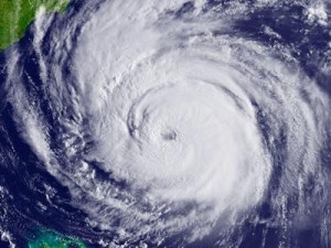
The parts of a hurricane are as follows: the center of the hurricane is called the eye. This is where there is sinking air and subsidence, which causes the clouds to break and the sun to come out. In the eye, winds diminish to light or even calm. This does NOT mean the effects of the hurricane are over!!! Once the eye passes your area the strong winds and rain return. Surrounding the eye is the eye wall. This is the area where some of the heaviest rain occurs. Surrounding the eye wall are spiral bands. Tornadoes can form in the spiral bands due to intense severe thunderstorms.
Lastly, hurricanes are named to aware the public of the great danger they pose. When a hurricane is forecast to hit an area, evacuation of that area goes into effect. People who choose not to evacuate can be in danger due to tremendous flooding.
People can drown in flooding caused by hurricanes. Hurricane names alternate with male and female. If all the names in the alphabet are used, then names are chosen from the Greek alphabet. Because of their severe impact, hurricanes Katrina and Andrew will NOT be used gain. Their names are retired. Hopefully, this article gives you a better understanding of hurricanes and the danger they can pose.
 Al Kaprielian is a world famous meteorologist who has worked for several New Hampshire and Massachusetts media outlets. He is now an EXCLUSIVE columnist for The Valley Patriot. You can hear Al’s weather forecast daily on 980WCAP in Lowell as well as on the Paying Attention! Radio Program on Saturday Mornings at 10:35AM. Email your questions and comments to 7al61@comcast.net.