Tom Duggan: 03-24
Salisbury Beach is a complex barrier beach system, comprised of coastal beach, coastal dunes, and the Great Salt Marsh.
Memories of old Salisbury Beach with small summer cottages and fun-filled amusement parks have disappeared – torn down and replaced with overdevelopment of large multi-family homes, massive condos, and virtually no views of the ocean from the streets. Many thru-ways to the beach have vanished including the many lifeguard posts, and the historic thru-way to the beach next to the former Butch’s Club at lifeguard post #28.
Environmental advocates say overdeveloping the shoreline contributes to coastal erosion.
Yet, Salisbury’s Town Officials, Board of Selectmen/Sewer Commissioners, Planning Board, and Conservation Commission have disregarded State Executive Order 181 Barrier Beaches, U.S. EPA Step 3 Special Construction Grant Condition #18, and Federal Executive Order 11990 Protection of Wetlands.
Salisbury had to comply with the state and EPA sewer grant conditions regarding the barrier beach because conditions attached to grants the town has received.
In 1985 Salisbury agreed to U.S. EPA special grant condition #18 “The Grantee shall prohibit connections to the sewerage system from any new development built within a 100-year floodplain, wetland, or barrier beach (Salisbury Beach).” This was to comply with Executive Order 181 Barrier Beach restriction on building.
The proposed projects are new developments built within a 100-year floodplain, wetland, or barrier beach.
The state’s Beach Mall Contract #6 sewer construction was included in the EPA/State sewer project. This is where the Big Block proposed project is to be constructed.
Through the years since the EPA sewer project, Salisbury has allowed construction of many new developments located in the barrier beach area and the Great Salt Marsh, i.e. Tidewater at Beach Rd. which has approximately 210 units as well as other smaller developments on Beach Rd., North End Blvd., Old County Road, etc.
Flooding:
Most of the beach was flooded in January 2024. People at the beach could not leave the beach! On Jan. 10th multiple vehicles became disabled and stranded, Salisbury police officers assisted firefighters with Special Operations Humvee in rescuing the operator of a vehicle and transported him to safety as water levels continued to rise and then assisted on a medical aid call in evacuating a patient from North End Blvd. to an awaiting ambulance past the flooded area. Beach Road and Route 286 were both impassable making it difficult for emergency vehicles to respond.
Now many property owners are very concerned because during coastal storms it is impossible to leave the beach due to the high water coming from the ocean, through Broadway, onto Beach Road and North End Blvd. and also much flooding coming from the Great Salt Marsh covering Beach Road, where several new developments are located, and Old County Rd.; a canoe was needed to travel down Dock Lane.
Dune Erosion:
Since 2004 Coastal Zone Management, to no avail, has warned and sent letters to Salisbury Town Planner Lisa Pearson and Town Manager Neil Harrington of their concern “that inappropriate development will adversely affect the barrier beach” and recommended that “the Town take both current flooding conditions and erosion rates into consideration when planning zoning changes [for the beach]….” and advised Salisbury to defer its proposed zoning changes in the beach commercial district.
Expense to state and property owners:
The state has spent thousands on beach accesses for staircases that were destroyed by coastal storm damage that caused erosion of the dunes. FEMA has provided funds to construct a sacrificial dune. Many property owners incurred damage and paid for sand for their dunes.
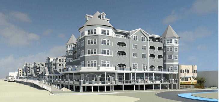
Big Block is also now known as One Oceanfront South project.
The Planning Board approved the project and on Sept 6, 2023 the Salisbury Conservation Committee approved the One Oceanfront South project even though it is in violation of the Town’s grant condition #18 and Executive Order 181.
The Big Block area is on a coastal dune and wetland. Even though Wayne Capolupo plans on building sand dunes as part of the project, artificially created dunes do not necessarily respond to storms the same way as natural dunes.
Big Block Development Group’s One Oceanfront South Project would be located from the corner of Broadway and Oceanfront South approximately 235 residential units in a FIVE-STORY building plus 7,500 square feet retail space.
Is it a coincidence that the “boardwalk to nowhere” is directly where Wayne Capolupo’s Big Block Project is planned?
1980 Executive Order 181: Barrier Beaches
Governor King wrote that the Commonwealth seeks to mitigate future storm damage to its barrier beach areas. State agencies were ordered to adopt 7 policies, i.e. “State funds and federal grants for construction projects shall not be used to encourage growth and development in hazard prone barrier beach areas.”
1977 Executive Order 11990: Protection of Wetlands
President Carter wrote to “avoid … the long and short term adverse impacts associated with the destruction or modifications of wetlands and to avoid direct or indirect support of new construction in wetlands ….”
See: The Valley Patriot February, 2020 article entitled “Who Will Enforce the Law in Salisbury?” ◊
